Spent the evening working on site maps.

The event’s Saturday. We need to have a map of the site – where the official tents go, where the unofficial tents go, guide rope issues, that sort of thing – by Friday night, so that we can get the big tents up then and coordinate the smaller ones on Saturday. So I spent the evening scribbling away on the computer. Fortunately, the site is dead easy to draw.

It’s funny. Everywhere else, my ability to make maps on the fly was subject to at least mild respect and approval. I never had anybody gasp, but they were impressed. But in the SCA, it’s… expected, really. After all, we all learned it the same way: via D&D.

I need a good *physical* map of Eastern North America.

It needs to be larger than a standard piece of paper, and I don’t want cities or boundary lines on it: I need to be able to add them on my own.  Color’s not necessary: in fact, black and white would be ideal, but I doubt that they sell black-and-white physical maps at the size that I need it in. I also don’t care to spend sixty bucks on this, either.

Any suggestions?

Tweet of the Day, Apparently Map-Haters Are A Thing edition.

I’ve never experienced this for myself, but the tone is so instantly believable that I cannot help but believe that there are people who do this in real life. Then again, I do a plurality of my creative work in alternate/secret history stuff, which does tend to cut down on the need for new physical maps.  So for all I know there are entire forums where people do this sort of thing for real.

My PJ Lifestyles article on campaign cartography.

Found here.  Short version: it’s about maps in RPGs, which will of course immediately spark an animated discussion about maps in RPGs, because people who play RPGs love them some maps.  Seriously, it’s not quite universal, but the odds are good that any given gamer has, at some point, sat down and drawn a map or two. Or twenty.

It is the way of my people.

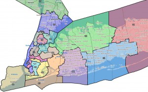
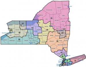
The THREATENED NY Congressional District map.

I say “threatened” because if the NY state legislature doesn’t come to a deal by Wednesday, this is the map that is very likely going to be the one to get used:

…and there’s going to be several Members of Congress who will be very unhappy if that happens.  Including Steve Israel of the DCCC. Continue reading The THREATENED NY Congressional District map.

Swear to God, I said “Goode Homolosine…”

and xkcd has me pegged.  Doubly, in fact: I also like the Robinson map.

And if you to were wondering what the big deal is about the Gall-Peters map projection, check it out.  I already knew that cartographers were very, ah, enthusiastic about their craft; but I’m legitimately shocked that this controversy didn’t end with knives in the sewers.

Moe Lane